2018年5月 ハワイ キラウエア噴火、地震; 備忘
| Hawaiian Volcanism / Volcano World Your World is Erupting - Oregon State University |  アメリカ / ホノルル(ハワイ)の時差と現在時刻 アメリカ / ホノルル(ハワイ)の時差と現在時刻日本の方が、19時間進んでいます。 |
Hawaii Newspapers & News Media - ABYZ News Links |
| ← キラウエア火山 (ハワイ) −−− / 2017-02-09 ← ハワイの地震 と 火山活動 (備忘) / 2015-05-19 ← ハワイの火山; Hilina Slump ヒリナ地滑り (備忘) / 2014-10-30 ← ハワイの火山; キラウエアの溶岩、まちに到達 / 2014-10-29 ← ハワイの火山; キラウエア噴火 (溶岩を流出するタイプ) / 2014-09-23 |
キラウエア火山の活動が活発化;
USGS Volcano Hazards Program HVO Kīlauea
- Kilauea Alert Level: WARNING, Color Code: ORANGE
2018-05-05 02:04:43 UTC
- Volcano bits and bites - New fissure eruptions + strongest earthquake so far, Kilauea volcano, Hawaii
Last update May 5, 2018 08:56, Earthquake-Report.com
-
- Strongest earthquake since the Kilauea volcano swarm started, Hawaii - Fissure eruption started May 3, 2018
Last update May 4, 2018 05:25, Earthquake-Report.com
- Strongest earthquake since the Kilauea volcano swarm started, Hawaii - Fissure eruption started May 3, 2018
-
- Very strong earthquake - Leilani Estates, Hawaii - May 4, 2018
Last update May 4, 2018 23:35, Earthquake-Report.com
- Very strong earthquake - Leilani Estates, Hawaii - May 4, 2018
- Volcano news & updates: Kilauea volcano (Big Island, Hawaii)
VolcanoDiscovery
関連報道;
- Hawaii’s Kilauea volcano continues to erupt amid earthquakes. Here’s how things could get worse
May 4, 2018, 4:25 PM, The San Diego Union-Tribune
- 米ハワイでM6.9の地震、キラウエア火山がまた噴火
2018年5月5日 13:58 発信地:ロサンゼルス/米国、AFPBB News
火山活動・地震発生状況;

出典: Interactive Map of Active Volcanoes and recent Earthquakes world-wide - all EQs (実際には only quakes >=M.2 ?) past 2 weeks, all volcanoes で表示

出典: Hawaii 7 Days, All Magnitudes U.S.
冒頭テーブル (過去記事 でも紹介) の オレゴン州立大学サイト によれば;

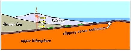
”a schematic cross-section through Kilauea and part of Mauna Loa, viewed towards the East. This shows how the seaward flank of Kilauea (and part of Mauna Loa) is pushed southward (to the right) by the intrusion of dikes down the rift zone (away from you into the plane of the diagram). This huge bulk of volcano is probably sliding on ocean sediments that accumulated on the ocean floor during the 90 million or so years between the time that our particular part of Pacific Plate formed and when the Big Island of Hawai'i started to grow.”

”Map showing most of the large 'a'a and pahoehoe flows on Hawai'i. This information can be used to attempt to understand the plumbing of the rift zones as well as to characterize volcanic hazards (From Rowland & Walker 1990).”
面白そうなイベント;
.
