イラン北西部 大地震: 現地時間 2012年8月11日(土) (速報)
現場でのレスキューは一区切り、死者250名・負傷者2000名以上との報道;
◆Iran Ends Rescue, Relief Operations in Quake-Hit Regions
14:29 | 2012-08-12, Fars News Agency
−−−An earthquake measuring 6.2 on the Richter scale jolted Ahar in East Azerbaijan province at 16:00 hours local time (1130GMT) Saturday. The epicenter of the quake was located in an area 46.8 degrees in longitude and 38.4 degrees in latitude. / Almost an hour later another quake with magnitude 6 on the Richter scale jolted Varzaqan at 17:04 hours local time (1234GMT) in the same province. The epicenter of the quake was located in an area 46.7 degrees in longitude and 38.4 degrees in latitude. (以下略、引用終わり)
※ どうもよくわかりませんが、最初の地震発生の時刻がおかしい。おまけに2回目との間隔が1時間? 変なつじつまあわせの様な−−− MehrNews.com の報道 "The quakes struck at 4:53 p.m. and 5:04 p.m. local time" なら矛盾が無いのですが−−−
なお死傷者数に関しても、 死者は227人、負傷者は1380人 なるAFP=時事の報道とも食い違う。
■ イラン北西部でM6超の地震相次ぐ・人的被害多数(8/11)
随時更新、rescuenow.net
■ イランの時差と現在時刻
Time-j.net
※ サマータイム中 / ・タイムゾーンの名称:IRDT / ・協定世界時との時差:UTC+4:30 / ・日本時間との時差:JST-4:30 / 日本と イラン との時差は、4時間30分です。日本の方が、4時間30分進んでいます。
◆Two earthquakes kill 250, injure 2,000 in northwestern Iran
Sat Aug 11, 2012 10:24PM GMT (更新中の様子)
※ 地震発生時刻の表記が明らかに間違ってますね。1123 GMT とありますが、Iranian Seismological Center のデータでは 2012/08/11 12:23:15.3 、EMSC および USGS でも 1223 ですから。それにつられて現地時刻も間違い。夏時間の計算間違い?
◆Iran earthquakes in photos
Tehran:04:09, 8/12/2012 @ Mehr News Agency
◆Iran earthquakes in photos
Tehran:03:51, 8/12/2012 @ Mehr News Agency
※ 被災現場の写真多数
◆
Iran earthquake kills 153 people (地震が単数形)
TalentTOP さんが 2012/08/11 に公開
◆
دو زمینلرزه نسبتا شدید شمال غرب ایران را لرزاند (ペルシャ語)
jeanroustan さんが 2012/08/11 に公開
◆Scores killed in northwest Iran earthquakes
At least 180 dead after twin earthquakes strike near town of Tabriz
Last Modified: 11 Aug 2012 22:09, Al Jazeera English

◆More than 150 killed, 400 injured in Iran earthquakes
Head of the country's emergency department says injured residents have been transferred to hospitals in the provincial capital of Tabriz
By DPA and Reuters | Aug.11, 2012 | 8:30 PM @ Haaretz Daily Newspaper

■ Iranian Seismological Center TOP

出典: Latest Earthquakes Map
※ 詳細インデックスは地図下方に表示
今回の震源を擁するイランの州(オスターン)。イラン北西部に位置し、アルメニア共和国、アゼルバイジャン共和国およびアルダビール州、西アーザルバーイジャーン州、ザンジャーン州と境を接する。州都はタブリーズ。 (以下略、引用終わり)
■ Earthquakes - Earthquake today - Latest Earthquakes in the World - EMSC

出典: Earthquakes Zoom - LAT 34 - 44 ; LON 44 - 54
※ 地図下方に詳細インデックスあり。
■ Latest Earthquakes in the World - Past 7 days - USGS

出典: 10-degree Map Centered at 40°N,45°E
詳細: List of Earthquakes on this Map
イラン北西部 大地震: 現地時間 2012年8月11日(土) 続報など
⇒ 速報
速報がごちゃごちゃして来たこと、地震直後のレスキューがひと段落したらしい (まだ未救助の村もある様子) ことから、以下続報とします;
◆<イラン地震>犠牲者の多くは女性、子ども…余震続く
毎日新聞 8月12日(日)20時2分配信
今回の本震2つを除くM2.5以上 (有感?) の余震数は、2012/08/12 10:15:33.0 (UTC) までの22時間で計143回!
⇒ Iran 11Aug12.xls ![]() (情報源など明記してあります)
(情報源など明記してあります)
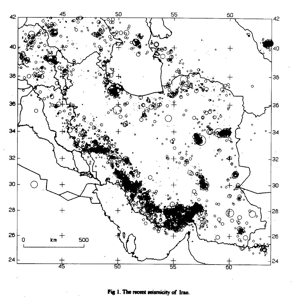
この地域では、もちろん過去にも散発的に地震はあったものの2006年以来最大でM4.6、過去の震源マップを見ても空白域に近かったため備えが無く、深さ10キロ程度のM6クラスの揺れでは建物はひとたまりもなかったでしょう;

出典: The recent seismicity of Iran / GLOBAL SEISMIC HAZARD ASSESSMENT PROGRAM
※ データ期間の明示無し
参考: •Historic Earthquakes in Iran
【震源地】
◆Magnitude 6.4 - NORTHWESTERN IRAN
2012 August 11 12:23:17 UTC

※ クリックして原寸

※ クリックして原寸
■ Administrative divisions / East Azerbaijan Province

※ クリックして原寸
■ Explanatory Notes to the Map of Major Active Faults of Iran

※ クリックして原寸

■ International Institute of Earthquake Engineering and Seismology

※ クリックして原寸
アラビアプレートとの境界からは距離があるし、大きな断層の確認された地域でも無いし、震源も9.9キロと浅い。余震も続いている様ですが、どんなメカニズムによるものか??
.